I've posted many of these maps on my facebook group Randolph County Indiana History, but facebook over the years has changed how groups are run several times, and these maps cannot always be found, many new to the group have never seen them, so this is one of the many reason I've started this blog. It also give people who are not on facebook a chance to research for themselves Randolph County Indiana History.
Enjoy these maps.

1804 (9 years after the signing of the Greenville Treaty at Ft. Greeneville, Ohio) Our Randolph County is in the green area, the boundary is our Boundary Pike. This area was surveyed by Israel Ludlow.
Click on the map to get a full view.

Here is a closer look.
In 1809, more land was acquired through treaty. This moved the boundary line some 12 miles (called the 12 mile boundary) to the west and then in Ridgeville to Fort Recovery a new line was drawn. The war of 1812, brought soldiers, assembled at Fort Greeneville, through our Randolph County, much of the land untouched by the White Man's world. As soldiers marched onto that battle in December of 1812, the sights of area gave promise to those eyes. Giving future settlers stories of this land. For more details you should read the 1882 Randolph County Indiana History book by Rev. Ebenezer Tucker (future posts about him coming soon). This area was never called Randolph County during the Indiana Territory days, that was towards the south part of the state near the Illinois boarder. In the days of fur trappers, native encampments and traveling hunting parties, of men such as David Conners, Adam Fluke , the area was a part of Dearborn County as Dearborn Territory or Dearborn State (1882 RCI History by Tucker page 28) in 1803. Wayne County was formed out of the northern part of Dearborn County in 1810, containing most of the southern 3rd of our county in it. The state was created in 1816 and Randolph was officially a county by 1818. Even then the boundaries of Randolph County changed, to go to the north at the state line with Michigan, which made the early days of Ft. Wayne a part of Randolph County. This changed in 1836. when several other counties had taken their boundries including Jay County, defining our current northern boundary. Interestingly, the first established community was Arba in 1814 and still exists, but doesn't appear in these maps until 1888.

This map is dated 1839
Here you will find Macksville, Windsor, Hunts Cross Road, Mississenawa, Randolph (the first one was at the intersection of Boundary and Greenville Pikes) and Lyme along with Winchester.
You will also see the 1795 and 1809 treaty lines.

This map is dated 1840, Hunts Cross Road is now listed as Huntsville.
Deerfield made the map, it is likely the settlement of Mississenawa but drifted slightly south. Little is know of the community of Mississenawa.

This map is dated 1845, here you will find Ward, Mt. Holly, Howntown, Bloomingport and Spartanburg. Bloomingport and Spartanburn still exist today.

This map is dated 1850 and notes Union (City) and the Indiana Bellefontaine Rail Road.
Another Rail Road Map from the 1850s.

This map is dated 1852, and shows FairView, Steubenville, Emmettsville, Ridgeville, Deerfield, Ward, New Middletown, Mt. Holly, Allensville, New Lisbon, Morristown, Farmville, Windsor, George Town, Unionport, Huntsville, Losantville, Royston, Macksville, Winchester, Buena Vista, Springboro, Lynn, Bloomingport, Union, Salem, Randolph, Bartonia, and Spartanburg.

This map is also dated 1852.
This map is dated 1854.
This map is dated 1855, shows the many Rail Roads that came to Union (City).

This Map is dated 1858 and shows the Rail Road going through Morristown, Farmland, Winchester, Harrisville & Union.

This map is also dated 1858, it shows some proposed Rail Roads in the county, some were built and some were not.

This map is dated 1859.
Another 1859 map.
This map is dated 1860.
This map is dated 1860.
This map is dated 1861.
In 1865 a wall map with property owners was published. There are a few originals still around, but here is a digital one. Follow this link to that map http://www.loc.gov/item/2013593178
This map is dated 1868. This the first time Saratoga is posted on these maps, the depot there was called Warren.

This map is dated 1871.

This map is also dated 1871.

This map is dated 1872, you will see a proposed Rail Road connecting Versailles, OH to New Castle, IN going through Randolph County. It was not built.

This map is also dated 1872.

This map is dated 1874. Snow Hill is on this map.
There is also another 1874 map that lists land owners. Find it here http://www.historicmapworks.com/Atlas/US/7835/Randolph+County+1874/

This map is dated 1881, you will see the depot Warren in this one, and Stone (Station) and Woods (Station) (now Rural). There is also Johnson, which only flourished for a short time. Morristown is now listed as Parker.

This map is also dated 1881.
This map is also from 1881.
In 1882, the Randolph County Indiana History Book by Rev. Ebenezer Tucker published land owner maps broken up by named townships. A great resource for the researcher to use. http://www.historicmapworks.com/Atlas/US/9252/Randolph+County+1882/
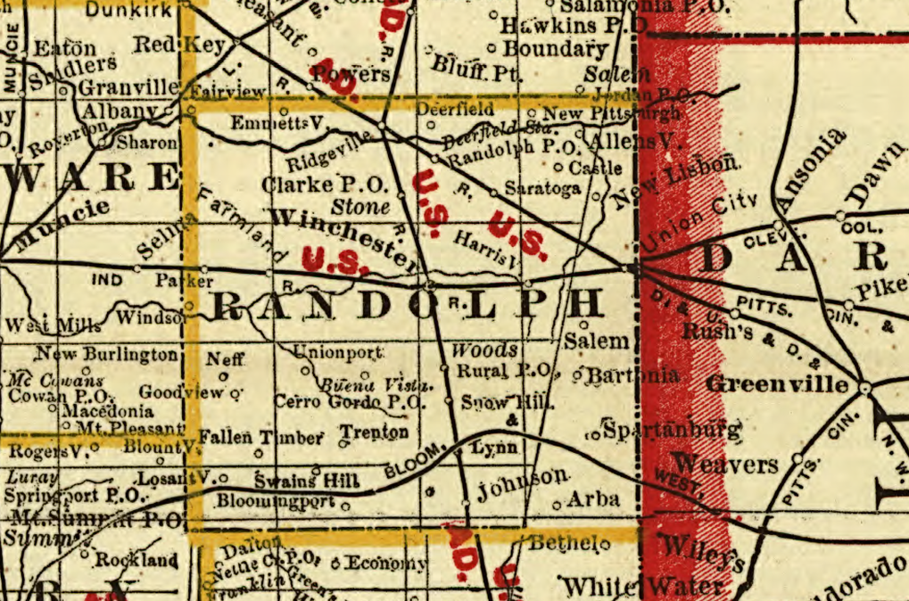
This 1888 map is different, it lists towns with their Post Office Names also for some of them. Like Woods (Station) is also the Rural Post Office, Deerfield Station is also the Randolph Post Office, Stone (Station) is also the Clarke Post Office, Buena Vista is also the Cerro Gordo Post Office. Some communities are just listed by their Post Office like Fall Timber, Trenton, Swains Hill and Castle. This is also lists the first time New Pittsburgh and Arba are listed in these RR maps. Also Other new Postal Communities Neff and Goodview are also listed, Note that several communities are not listed in correct locations.
More on Post Offices in another Post.

This map is dated 1893.

This map is dated 1896-1897; it lists for the first time several small Post Offices. Brinkley, Horn, Randolph (the second one, just south of Deerfield on the Rail Road Line and today's US 27), Sherman, Bragg, Modoc, Carlos City Station & P.O., and Crete.
Another unique thing with this map is that it names the townships.

This 1898 map is fun, it has fun with some of the names of the communities. Some of the communities are a little off. New to the maps is Mull Post Office (today's Lickskillet) and Rickert
It is believed that Chamness was orginally in Randolph Co, but drifted into another county.
This map is from the 1908 Randolph County Indiana Directory. I will post the directory here.
Take a peek at maps from 1933 http://www.historicmapworks.com/Atlas/US/10557/Randolph+County+1933/
Many of these maps I found are from Railroad reports that I found on books.google. I will try my best to find the source of each and post the links as I find them
Even with a map, we can be lost, without the one true Guide.
Andrea